Protecting source water is one of the most effective and cost-efficient ways to ensure public health protection while maintaining our water resources for us and our environment.
Everything we do affects the health of the groundwater, streams, rivers and oceans that make up our source water supplies. When it rains; soil, pet waste, yard waste, pesticides, fertilizers, salt, oil/grease, litter and other pollutants get washed into the storm drains that empty into our lakes and rivers.
We encourage you to read on to learn what the province, municipal units and Halifax Water do to protect our water supply; and what community stakeholders - businesses, residents and visitors alike - can do to ensure that Halifax's drinking water supply is as clean and safe as possible.
We are looking for feedback from members of the communities in and around this protected water area.
With support from the Board and the Province, Halifax Water will host public engagement sessions to help inform and seek input on potential amendments to these provincially protected water area regulations.
What is Source Water?
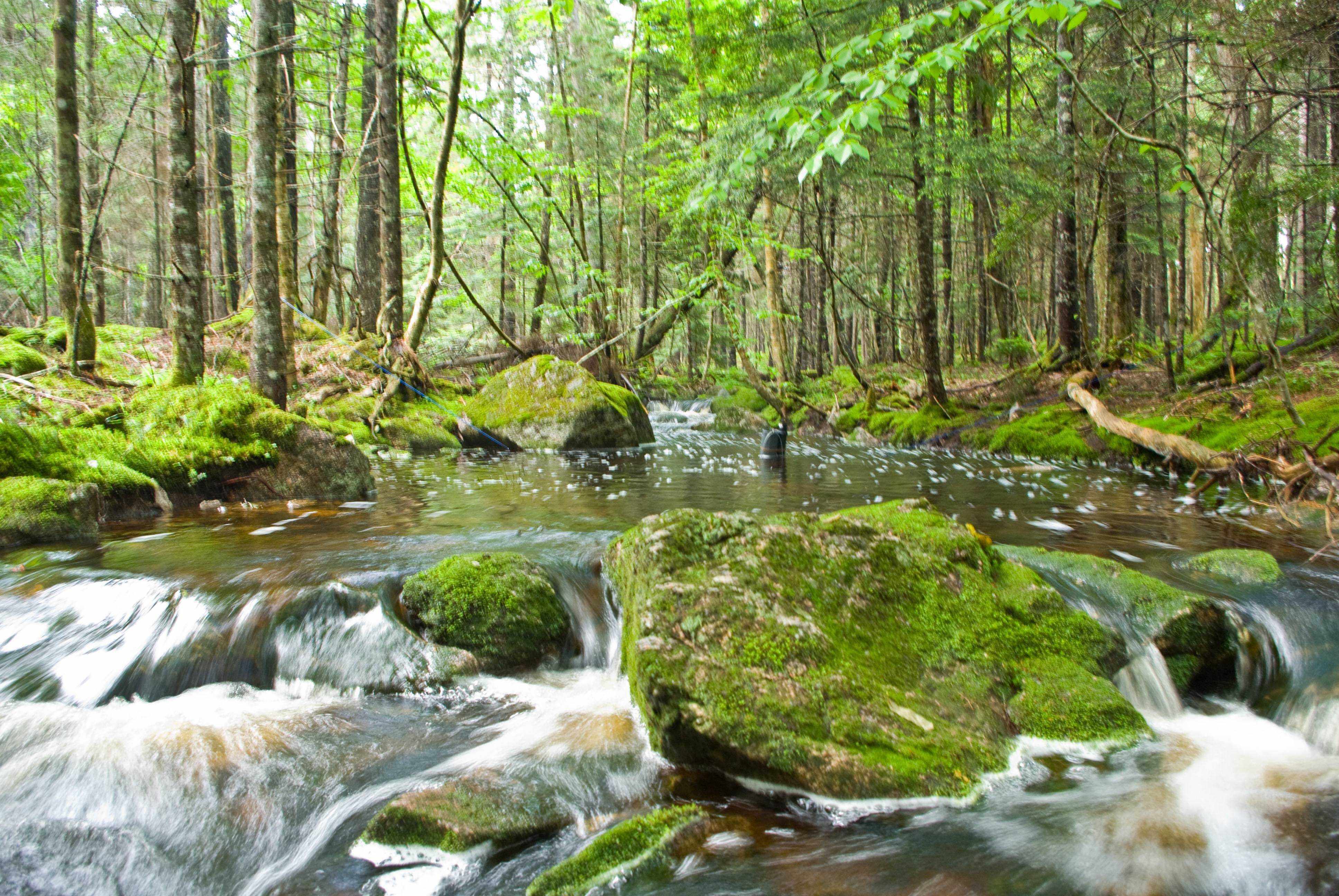
Source water refers to the lakes, rivers, streams and groundwater where our drinking water comes from.
The goal of source water protection is to maintain or improve the quality of drinking water before it reaches the water supply plant and eventually our taps.
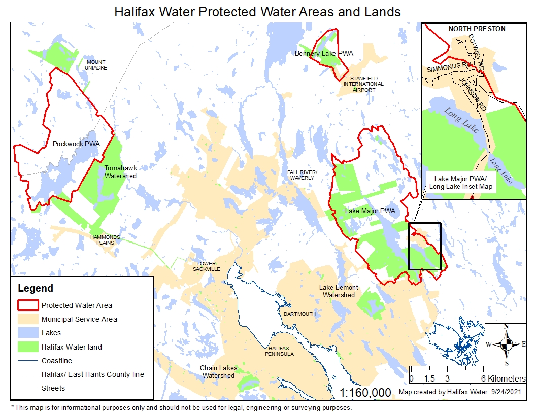
You can view the Source Water Areas map in a new browser window.
Testing and Monitoring Our Water Sources
Keeping water clean is the most effective way to sustain our drinking water resources for future generations.
Halifax Water manages 9 surface water supply areas (watersheds) and 2 groundwater supply areas (wellheads) [PDF] that together provide drinking water to over 355,000 customers in the Halifax Regional Municipality.
Each year more than 62 water sample sites are monitored, and over 7500 tests are conducted in the source water supply areas to ensure that Halifax's drinking water supplies are as clean and safe as possible. The data collected from these monitoring sites helps to identify the risks to the drinking water supplies. This information is then used to assist staff in making strategic management decisions to reduce or eliminate the risks.
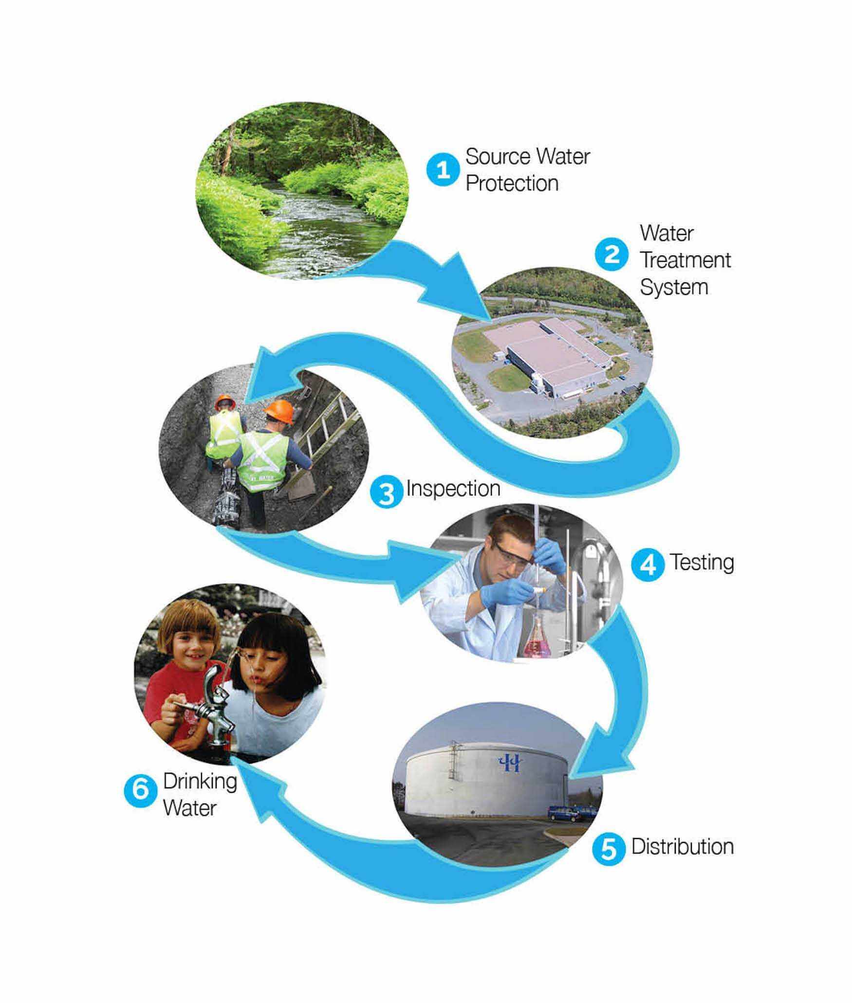
Source water protection is the first step in Halifax Water's Multiple Barrier Approach, which is a series of checks and balances to produce high-quality water from the water source to the customer's tap and back to the source that meets the Guidelines for Canadian Drinking Water Quality and Canadian Council of Ministers of the Environment Water Quality Guidelines for the Protection of Aquatic Life.
Every ocean, lake, river and stream is connected to a watershed. We all live, work and play in a watershed; from big city streets to small town backyards and from forests to farms.
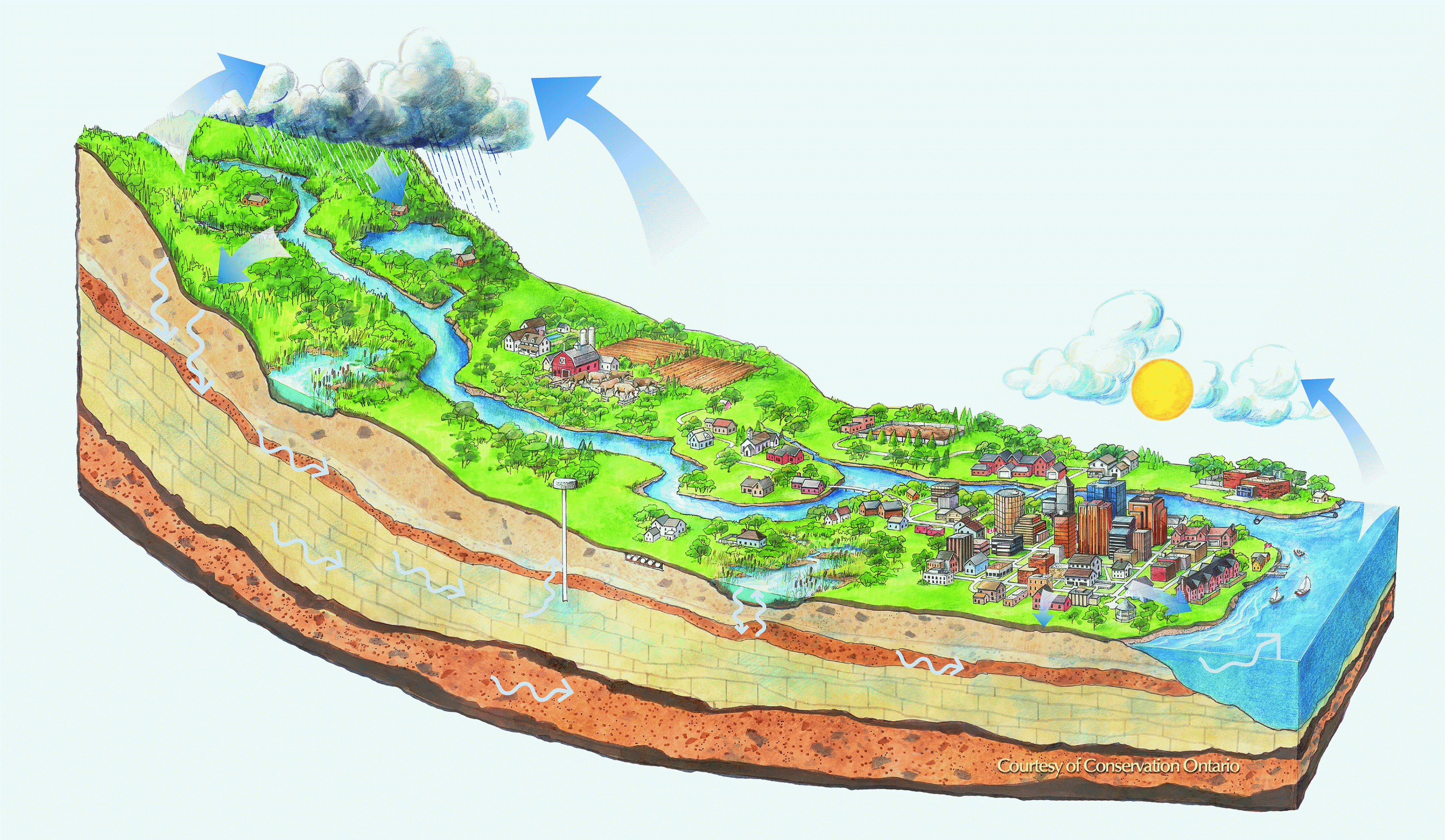
A watershed is an area of land where all water drains into a common water body such as a lake or ocean, or is absorbed back into the ground through groundwater recharge (wellhead areas). Watersheds vary in shape and size from thousands of hectares, like the Shubenacadie River watershed that flows from Lake Charles to the Minas Basin, to a few hectares that drain into a pond.
Water knows no boundary, which means that watersheds like the Shubenacadie River may cross municipal boundaries, while others like the St. John River watershed cross provincial and even international boundaries.
Halifax Water Watershed Water Supply Areas
- Covers approximately 5,661 hectares;
- Primarily owned by the Crown, of which approximately 86% is protected by provincial designation and regulations;
- Remaining 14% is private landownership located outside the designated area that is subject to the Halifax Regional Water Commission Act [PDF] and Municipality of East Hants Community Plan policies and Land Use Bylaw; and
- The watershed area is managed by Halifax Water in partnership with the Nova Scotia Department of Lands and Forestry and the Municipality of East Hants.
Pockwock Lake Watershed Protected Water Area Designation and Regulations
Pockwock Watershed Management Committee [PDF]
Pockwock Watershed Management Committee Meeting Minutes:
(Meeting minutes will open as a PDF document.)
- Primarily owned by Halifax Water (~75%) and protected under the Halifax Regional Water Commission Act [PDF] and by Halifax Regional Municipality policies and bylaws;
- Managed as a future water supply supplement for Pockwock Lake; and
- Actively managed by Halifax Water, in partnership with the Nova Scotia Department of Lands and Forestry.
- Encompasses approximately 7,000 hectares, and is protected under provincial designation and regulations and is subject to the Halifax Regional Water Commission Act [PDF] and Halifax Regional Municipality Community Plan policies and Land Use Bylaws;
- Approximately 30% of this designated watershed area belongs to the Waverley-Salmon River Long Lake Wilderness Area, which is protected under the Wilderness Areas Protection Act; and
- Approximately 30% of this designated watershed area is part of the Waverley Game Sanctuary [PDF], which is regulated under the Wildlife Act [PDF].
Lake Major Watershed Protected Water Area Regulations
Lake Major Watershed Advisory Board [PDF]
Lake Major Watershed Advisory Board meeting minutes/Notes:
(Meeting minutes will open as a PDF document)
*Please note there are no Minutes between October 2021 and March 2024 due to lack of quorum at the meetings within this period.
- Located north of the Bedford Basin, in the community of Oakfield, west of Highway 102 and the Aerotech Business Park;
- Appoximately 660 hectares of the designated watershed area is protected under provincial designation and regulations and Halifax Regional Municipality Community Plan policies and Land Use Bylaws; and
- Landownership consists of approximately 50% Halifax Water lands, 30% Crown lands and 20% privately owned land; and
- Entire Bennery Lake shoreline is owned by Halifax Water and the Crown.
Bennery Lake Watershed Protected Water Area Regulations
Bennery Lake Watershed Management Committee [PDF]
Bennery Lake Watershed Management Committee meeting minutes/Notes:
(Meeting minutes will open as a PDF document)
*Please note there are no Minutes between March 2022 and October 2023 due to lack of quorum at the meetings within this period.
- Located west of Northwest Arm Drive in Halifax, and serves as the emergency back-up water supply for the Pockwock system;
- Approximately 217 hectares;
- Over 95% jointly owned and managed by Halifax Water and the Crown; and
- Protected by the Halifax Regional Water Commission Act [PDF] and Halifax Regional Municipality policies and bylaws.
- Located in the community of Westphal and serves as the emergency back-up water supply for the Lake Major system;
- Approximately 368 hectares;
- Halifax Water maintains over 90% ownership; and
- Protected by the Halifax Regional Water Commission Act [PDF] and Halifax Regional Municipality policies and bylaws.
- Covers approximately 16,000 hectares;
- Subject to regulations under Halifax Regional Municipality policies and bylaws;
- Contains a portion of the Waverley-Salmon River Long Lake Wilderness Area, which is protected under the Wilderness Areas Protection Act; and
- Contains a portion of the Waverley Game Sanctuary which is regulated under the Wildlife Act [PDF].
Collin’s Park Watershed Advisory Committee [PDF]
Collin’s Park Watershed Advisory Committee meeting minutes:
(Meeting minutes will open as a PDF document)
- Encompasses approximately 33,300 hectares of the Musquodoboit River watershed, which includes over 25 km of the main river channel north of the community of Middle Musquodoboit.
Middle Musquodoboit Watershed Advisory Committee [PDF]
Middle Musquodoboit Watershed Advisory Committee Meeting Minutes/Notes:
(Meeting minutes will open as a PDF document)
Middle Musquodoboit Watershed Newsletters:
(Newsletters will open as a PDF document)
- Covers approximately 72,000 hectares;
- Includes the Collin's Park watershed area;
- Subject to regulations under Halifax Regional Municipality and Municipality of East Hants policies and bylaws;
- Contains a portion of the Waverley-Salmon River Long Lake Protected Wilderness Area which is protected under the Wilderness Areas Protection Act; and
- Contains a portion of the Waverley Game Sanctuary [PDF] which is regulated under the Wildlife Act [PDF].
A wellhead protection area is the surface and subsurface area surrounding a water well that is supplying a public water system, through which contaminants are likely to move toward and reach.
Time of travel zones
Wellhead areas are subdivided into three groundwater time-of-travel (ToT) zones for the purposes of source water protection planning and management. The delineation of these wellhead protection areas represent graduated levels of concern based on a calculated maximum time for a biological or chemical groundwater contaminant to reach the wellhead and are based on two-year (Zone 1), five-year (Zone 2) and minimum 20 year (Zone 3) ToT zone levels as defined below:
- Zone 1 is the two-year ToT zone that represents the greatest area of concern for protection from biological and chemical contaminants;
- Zone 2 is the 5-year ToT zone that represents the second-greatest area of concern for protection; and
- Zone 3 is the 20 plus year well recharge zone contributing to the aquifer relative to the wellhead location. This zone has been delineated for wellhead protection against persistent, mobile water quality contaminants.
Five Island Lake Wellhead Protection Area
- Serves as the water supply to approximately 10 customer connections in the Hubley/Five Island Lake area; and
- Encompasses approximately 135 hectares.
Silver Sands Wellhead Protection Area
- Serves as the water supply for approximately 40 connections in the Eastern Passage/Cow Bay area; and
- Covers an area of approximately 300 hectares.
Source Water Protectors: Keeping Water Clean
By working together we can keep contaminants out of waterways to keep water clean. Halifax Water relies on a number of approaches and municipal and provincial agencies to help protect Halifax Regional Municipality's public water supplies. The management tools employed and agencies empowered to help protect our water supply are described under the following headings:
The Province's Role In Water Protection:
The Nova Scotia Department of Environment and Climate Change is responsible for regulating water utilities under the Environment Act. Under the Act, water utilities may be able to designate an area of a water supply as a Protected Water Area (PWA) upon request and regulate activities that may impair source water quality. This is the most stringent form of governance available to Nova Scotia water utilities to manage their drinking water supply areas. Halifax Water is responsible for enforcing regulations in three of the province's designated PWAs.
Halifax Water Designated Watershed Protected Water Supply Areas and Regulations
Pockwock Lake, Lake Major, and Bennery Lake watersheds supply water to 99.95% of Halifax Water's customers. Each of these watersheds have a designated protected water area associated with them. Each PWA has associated regulations under the Nova Scotia Environment Act [PDF].
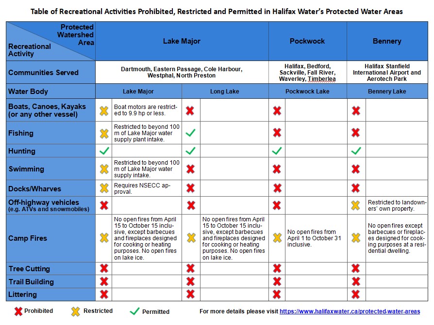
The table below compares the recreational activity regulations of Halifax Water's protected water areas, based on some of the most frequently asked questions around what recreational activity may be permitted in these areas.
In addition to these provincial designations and regulations, the Halifax Regional Water Commission Act [PDF] restricts activities in the Lake Lemont, Topsail, Long, Chain Lakes, and Tomahawk Lake water supply areas.
The Municipal Units' Role in Water Protection:
Recognizing that water knows no boundaries, the Municipal Government Act (MGA) [PDF] statement of 'Provincial Interest Respecting Drinking Water' requires municipal units to identify and address protection of all municipal drinking water supplies within their plan area.
The MGA also provides municipal units with the power to make bylaws to protect drinking water supply areas. In the Halifax Municipality, for example, the Regional Plan outlines the policies from which zoning bylaws are enabled to protect municipal drinking water supplies such as:
- Delineating Protected Water Supply (PWS) bylaw zones (independent of a provincial PWA area);
- Requiring setbacks from watercourses and/or creating riparian buffers in PWS bylaw zone areas and/or around all water bodies;
- Placing restrictions on phosphorus loading for new development; and
- Prohibiting activities that may put a water supply at risk.
Halifax Water's Role in Water Protection:
Halifax Water uses the multiple barrier approach to ensure safe drinking water is delivered to its customers, from source to tap.
To ensure clean and safe drinking water, Halifax Water's Source Water Protection Program implements the following:
- Dedicated staff to maintain a presence on watershed lands;
- Comprehensive source water protection plans;
- Acquisition of watershed lands when possible;
- Forest management in water supply areas;
- Monitoring of land use activities;
- Collection of water samples to identify and monitor potential sources of contaminants;
- Enforcement of drinking water supply regulations and bylaws;
- Collaboration with provincial and municipal regulators and other stakeholders including the development of its Best Management Practices [PDF];
- Engagement of outreach/educational opportunities with the public and other interested parties; and
- Industry-leading research opportunities.
Community Stakeholders: Keeping Water Clean
Watershed Advisory Committees/Board consist of representation from Nova Scotia Environment and Climate Change, Nova Scotia Department of Lands and Forestry, Halifax Regional Municipality and the Municipality of East Hants planning and development agencies, community groups, customers and other watershed users and stakeholders.
There are 5 Watershed Advisory/Management Committees/Boards that provide local support to Halifax Water. The terms of reference and minutes for each advisory board/committee are found under their respective headings in the Halifax Water Watershed Water Supply Areas section above.
Business activities such as development, construction and resource-based industries in or near water supply areas and near water bodies can diminish water quality. Contaminants generated from business activities include:
- Erosion and sedimentation from land clearing or road construction and maintenance;
- Poorly maintained erosion control devices;
- Chemical and oil runoff from machinery;
- Nutrient runoff from landscaping and fertilizer use;
- Spills and leakage from fuel containers;
- Improper disposal of refuse and garbage; and
- Runoff from malfunctioning drainage features.
To mitigate the impacts from business activities conducted within water supply areas, Halifax Water has an evolving document of Best Management Practices [PDF] for heavy equipment use, fueling, construction, maintenance, forest management and emergency response to protect source water by mitigating impacts to water supply areas.
How we live and use the land in water supply areas affects the quality of our drinking water. Many land uses and everyday activities can cause pollution to water supplies. Residents can help reduce their impacts and protect drinking water supplies by practicing the following:
- Creating a riparian buffer zone by allowing existing native plant species to establish near the water's edge;
- Using fertilizers with low to no phosphorus;
- Proper handling of all yard waste and clippings according to your local municipal program;
- Building or encouraging retention areas such as gardens and rain barrels on site, instead of allowing storm water to escape from your property;
- Undertaking routine inspections of on-site septic system and carrying out pump-outs every 3-5 years to lengthen the life of your system; and
- Reporting illegal dumping or suspicious activity in the water supply areas by calling 902-420-9287.
More information may be found on the Halifax Regional Municipality site under Energy & Environment.
Halifax Water wishes to inform the public that its watershed areas are managed to protect the water quality of its drinking water supplies. Permitted uses of watershed lands may be conducted according to Halifax Water policies and guidelines. If accessing a watershed area please:
- Contact Halifax Water for policies and guidelines.
- Be Prepared. Most of our watershed areas are considered remote and accessible only by foot. Have the equipment necessary to ensure your safe return.
- Be Safe. Let someone know where you are going, when you plan to return and stay on maintained roads and trails.
- No Littering. Pick up after your pet and carry out all garbage.
- Have Respect. Please read and heed posted signage, watershed regulations and land access policies.
Halifax Water Partnerships
Halifax Water creates and participates in meaningful partnerships with not-for-profit organizations and campaigns including:
Geocaching is a real-world, outdoor treasure hunting game using GPS-enabled devices. Participants navigate to a specific set of GPS coordinates and then attempt to find the geocache (container) hidden at that location.
Halifax Water has developed geocaching guidelines [PDF] in cooperation with the Atlantic Canada Geocaching Association.
These Guidelines facilitate safe and low-impact use of Halifax Water watershed lands by geocachers, while ensuring the protection of the quality of Halifax Water managed resources.
Halifax Water participates in research projects with academic and community organizations to support decision-making processes and provide insight on a number of issues that could impact source water protection. Research Projects Include:
- Pockwock Lake Study
- Pockwock-Bowater Watershed Study [PDF]
- Climate Change Impacts and Adaptations in the Forests of Central Nova Scotia [PDF], by James Steenberg, Dalhousie University M.E.S. Thesis (2010)
- The Development and Analysis of a Continuous Monitoring Network for Pockwock Lake [PDF], by Colin Ragush, Dalhousie University, Dalhousie University M.Sc. Thesis (2011)
- Microbial Source Tracking in Two Nova Scotia Watersheds [PDF], by Emma Stea, Dalhousie University M.Sc. Thesis (2013)
- forWater Research Project Training Resources: Created by forWater, a network of researchers working on innovative solutions to address climate change impacts on forested source water, the downstream effects, water treatability and resource economics.
Federal:
Provincial:
- Nova Scotia Environment Act [PDF]:
- Nova Scotia Municipal Government Act [PDF]:
- Off-highway Vehicles General Regulations
- Protection of Property Act
Municipal:
Contact Us
Phone
- 902-420-9287
